Port St. Lucie's 36 city-named neighborhoods in 12 areas, with ZIP codes, zoned high schools and August 2026 Zillow home values for each.
Last checked Oct. 10, 2026. Sources: the City of Port St. Lucie’s neighborhood map and parcel layer, St. Lucie Public Schools’ school locator, the Florida Department of Education’s 2026 school grades, the Zillow Home Value Index (Zillow Research), the Census Bureau and © OpenStreetMap contributors.
Port St. Lucie is a city of about 232,000 people, according to the Census Bureau’s 2020-2024 American Community Survey five-year estimates. The City of Port St. Lucie’s neighborhood map divides it into 36 named neighborhoods: 33 in 10 numbered planning areas and three newer ones in the west that carry no number. This guide groups them into 12 areas, each with its own page.
What this means for you
- Three highways shape the city. Interstate 95 runs north and south through the west side, Florida’s Turnpike through the middle and U.S. 1 along the east, with the North Fork of the St. Lucie River between the Turnpike and U.S. 1.
- School zones do not follow city or neighborhood lines. Check every address on the district’s school locator. Two areas inside the city are zoned for a high school in Fort Pierce.
- ZIP code home values ranged from $320,726 to $447,511 in August 2026, according to the Zillow Home Value Index, a modeled typical value, not a sale price.
How the city is laid out
The older neighborhoods, on the grid of streets and canals around Port St. Lucie Boulevard, lie east of I-95, in ZIP codes 34952, 34953, 34983 and 34984. St. Lucie West and Torino, planned communities in the north, use 34986. West of I-95, Tradition, Verano and Riverland are the newer, still-growing part of the city in 34987. The city’s parcel layer counts about 1,300 vacant residential lots in Tradition alone and about 2,000 in Riverland and Wilson Groves.
The main east-west roads are Port St. Lucie Boulevard (State Road 716 at its eastern end), Crosstown Parkway, which crosses the river to U.S. 1, Prima Vista Boulevard, St. Lucie West Boulevard, Gatlin Boulevard, Tradition Parkway and Becker Road. More in our getting around guide.
St. Lucie Public Schools runs every district school in the county, and its high school zones cross neighborhood lines. Elementary, K-8 and middle school places go through the district’s Student Assignment application. See our schools guide and home prices guide.
The 12 areas at a glance
| Area | ZIP code | Zoned high school | Typical home value, Aug. 2026 | Homes |
|---|---|---|---|---|
| Torino | 34986 | Fort Pierce Central | $372,418 | About 4,600 |
| St. Lucie North | 34983 | Fort Pierce Central | $361,472 | About 3,400 |
| St. Lucie West | 34986 | St. Lucie West Centennial | $372,418 | About 7,100 |
| Floresta, Bayshore and Northport | 34983, 34984 | Split: St. Lucie West Centennial, Port St. Lucie, Fort Pierce Central | $361,472 (34983) | About 18,400 |
| Gatlin Pines and Oak Hammock | 34953 | Split: St. Lucie West Centennial, Treasure Coast, Legacy | $397,936 | About 19,000 |
| Rosser Reserve and Becker Ridge | 34953 | Treasure Coast (Legacy in western Rosser Reserve) | $397,936 | About 13,900 |
| Sandpiper Bay and Lyngate | 34952 | Port St. Lucie | $320,726 | About 5,900 |
| Sandhill Crossing | 34952 | Port St. Lucie | $320,726 | About 7,200 |
| Southbend Lakes | 34984 | Split: Port St. Lucie, Treasure Coast | $394,493 | About 3,700 |
| Tradition | 34987 | Legacy | $447,511 | About 7,900 |
| Verano and Copper Creek | 34987 | Legacy | $447,511 | About 4,300 |
| Riverland and Wilson Groves | 34987 | Legacy | $447,511 | About 3,600 |
Zoned high schools come from our random samples of addresses on the district’s locator. Home values are Zillow’s figure for the ZIP code, which is often shared with other areas; Zillow’s figure for the whole city was $384,593 in August 2026. Homes are single-family houses and condominium units on the city’s parcel layer.
Map
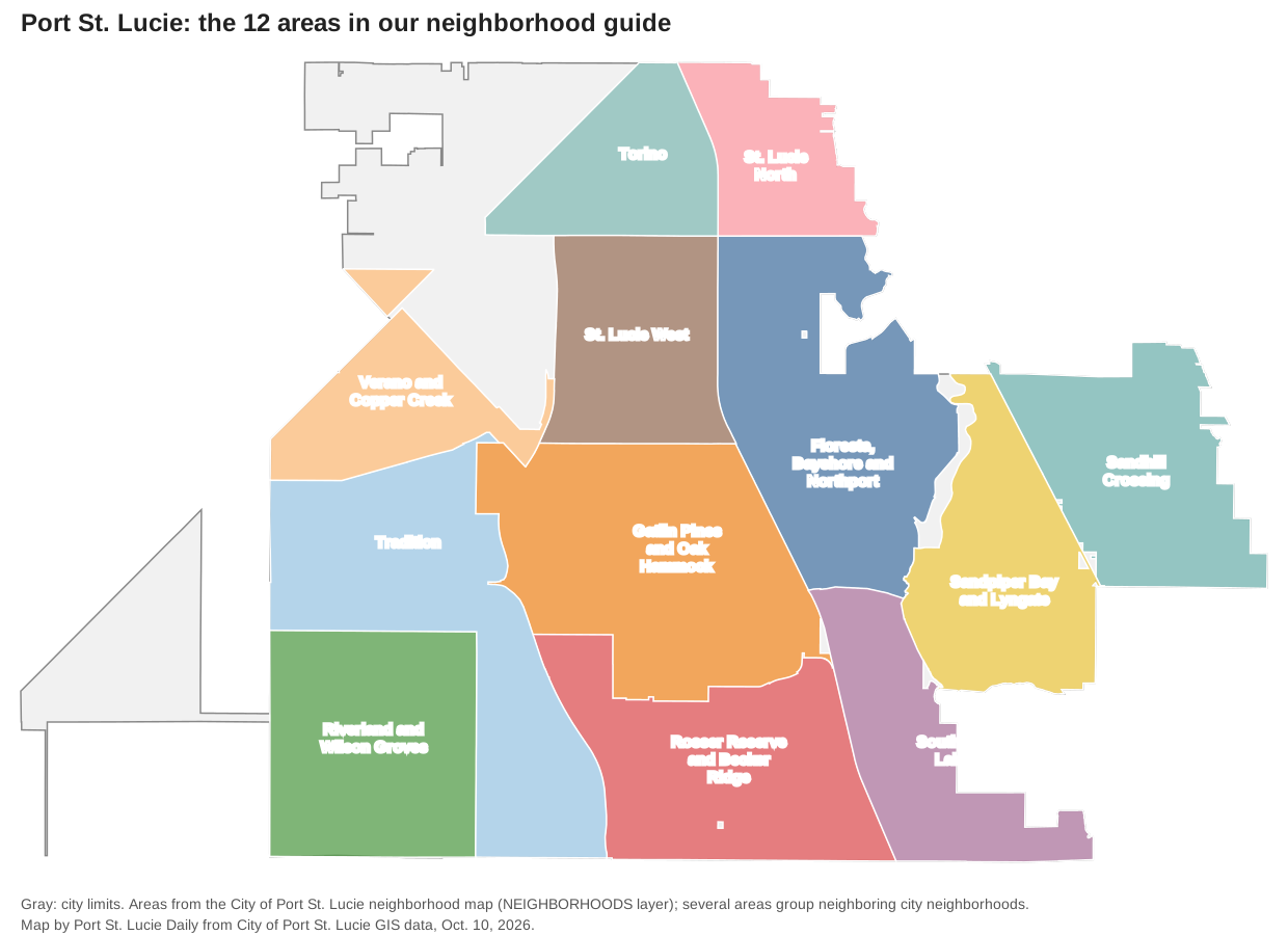
Map by Port St. Lucie Daily from the City of Port St. Lucie’s neighborhood and city limit layers. Several areas group neighboring city neighborhoods.
The areas
North
Torino (Planning Area 1) sits at the north end of the city on both sides of I-95, with Winterlakes Park and the planned Torino Regional Park. Homes are zoned for Fort Pierce Central High.
St. Lucie North (Planning Area 2) lies east of Florida’s Turnpike and south of Midway Road, with River Place Park on the North Fork of the St. Lucie River. It is also zoned for Fort Pierce Central High.
Middle
St. Lucie West (Planning Area 8) lies between I-95 and the Turnpike around St. Lucie West Boulevard, with Clover Park, the New York Mets’ spring training ballpark, and McChesney Park. It is zoned for St. Lucie West Centennial High.
Floresta, Bayshore and Northport (Planning Area 3) covers eight older neighborhoods east of the Turnpike, from Northport Village to Floresta Pointe, with Sportsman’s Park, Jaycee Park and C-24 Canal Park. It is split among three high schools.
Gatlin Pines and Oak Hammock (Planning Area 4 North) groups eight neighborhoods between I-95 and the Turnpike south of Crosstown Parkway, with Oak Hammock Park and Treasure Coast High on Darwin Boulevard.
South and east
Rosser Reserve and Becker Ridge (Planning Area 4 South) runs along Becker Road between I-95 and the Turnpike to the Martin County line, with O.L. Peacock Sr. Park’s lake beside I-95.
Southbend Lakes (Planning Area 5) lies east of the Turnpike around Becker Road and Southbend Boulevard, with Jessica Clinton Park.
Sandpiper Bay and Lyngate (Planning Area 6) lies between the North Fork of the St. Lucie River and U.S. 1 and includes The Port District, Lyngate Park and the Saints Golf Course.
Sandhill Crossing (Planning Area 7) lies east of U.S. 1, with Port St. Lucie High, Sandhill Crane Park and the MIDFLORIDA Event Center.
West of I-95
Tradition (Planning Area 9) is the city’s largest single neighborhood at about 12.9 square miles, around Tradition Parkway and Lake Tradition, and is zoned for Legacy High, which opened in 2025.
Verano and Copper Creek (Planning Area 10 and its northern neighbor) lie north of Crosstown Parkway west of I-95.
Riverland and Wilson Groves are the newest neighborhoods on the city’s southwestern edge, along Becker Road and Community Boulevard, with Riverland Paseo Park.
How we built this
- Areas: the City of Port St. Lucie’s neighborhood map names and draws neighborhoods across the whole city, and every area in this guide follows its lines. We grouped small neighboring neighborhoods with the same planning area number. OpenStreetMap’s place names inside the city limits are few and do not match the city’s neighborhoods, so we did not use them to draw areas.
- Homes and ZIP codes: the city’s parcel layer on Oct. 10, 2026, counting parcels with a state land use code for a single-family home or a condominium unit.
- Schools: random samples of homes in each area checked on the district’s school locator, with grades from the Florida Department of Education’s 2026 school grades.
- Home values: the Zillow Home Value Index for August 2026 by ZIP code and city.
- Distances on each area page are measured on the OpenStreetMap road network with the OSRM routing engine; they are distances, not drive times.
Comparing nearby cities? See Port St. Lucie vs. Fort Pierce vs. Stuart. Related: moving to Port St. Lucie, property taxes and parks and trails.
Frequently asked questions
What are the neighborhoods in Port St. Lucie?
The city’s neighborhood map names 36, from Torino and St. Lucie North in the north to Tradition, Verano and Riverland in the west and Southbend Lakes in the south. Our guide groups them into 12 areas.
What ZIP codes are in Port St. Lucie?
Six Census ZIP code areas cover most of the city: 34952, 34953, 34983, 34984, 34986 and 34987. A few homes at the southern edge use 34990.
Do Port St. Lucie school zones follow neighborhood lines?
No. St. Lucie Public Schools draws its own high school zones. Torino and St. Lucie North, inside the city, are zoned for Fort Pierce Central High in Fort Pierce, and four of our 12 areas are split between two or three high schools.
Which Port St. Lucie ZIP code has the highest typical home value?
34987, the western ZIP code that covers Tradition, Verano and Riverland, at $447,511 in August 2026, according to the Zillow Home Value Index. The lowest of the city’s ZIP codes was 34952 at $320,726.
Have your say